Volcanoes
A volcano is a geological structure that results from the rise of magma and then from the eruption of materials (gas and lava) from this magma, on the surface of the earth’s crust (or another planet). It can be aerial or underwater. Because it is linked with a rise of magma most of them are directly linked with tectonic plates and this explain the localisation of volcanoes on the world map.
Table of contents
- Structure of volcanoes
- Type of volcanoes
- Tectonic plates and volcanoes world map
- The Pacific Ring of Fire
- Top 10 biggest volcanoes in the world by height
- Recommended books
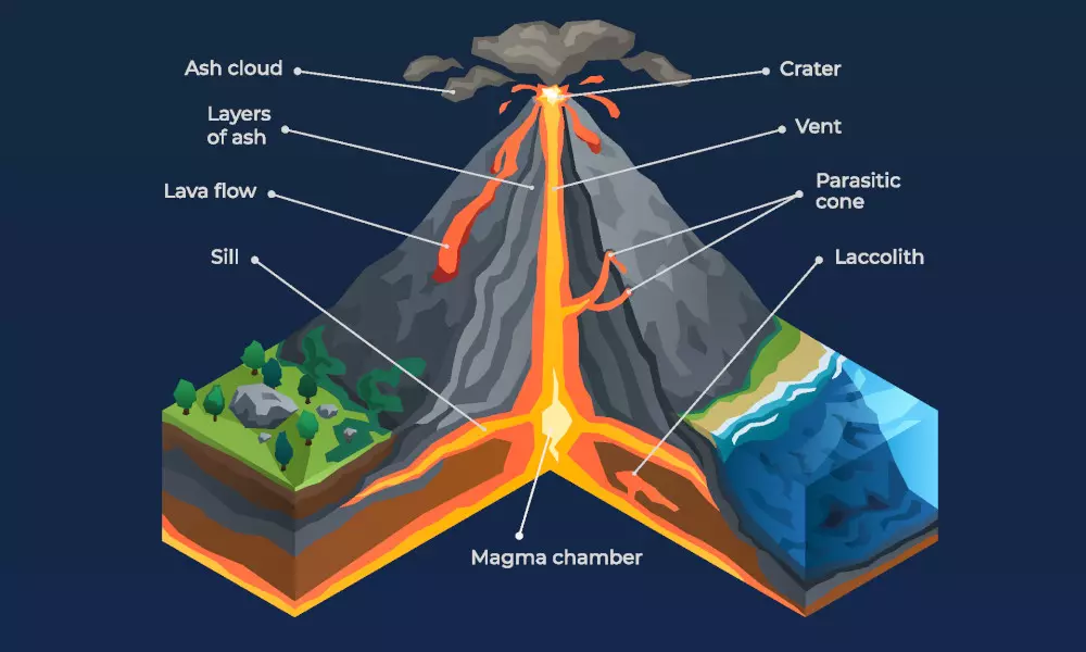
Structure of volcanoes
A volcano is made up of different structures that are generally found in each of them:
- Magma chamber: filled by magma coming from the mantle and playing the role of reservoir and the place of differentiation of the magma. When it empties following an eruption, the volcano can collapse and give birth to a caldera. The magma chambers are between 10 and 50 km deep in the lithosphere.
- Vent: pipe that conduct magma from the chamber to the surface.
- Crater (or a Caldera): place of the opening of the vent on the surface.
- Secondary volcanic vents: starting from the magmatic chamber or the main vent and generally leading to the sides of the volcano, sometimes at its base. Further, they can give rise to small parasitic cones.
Type of volcanoes
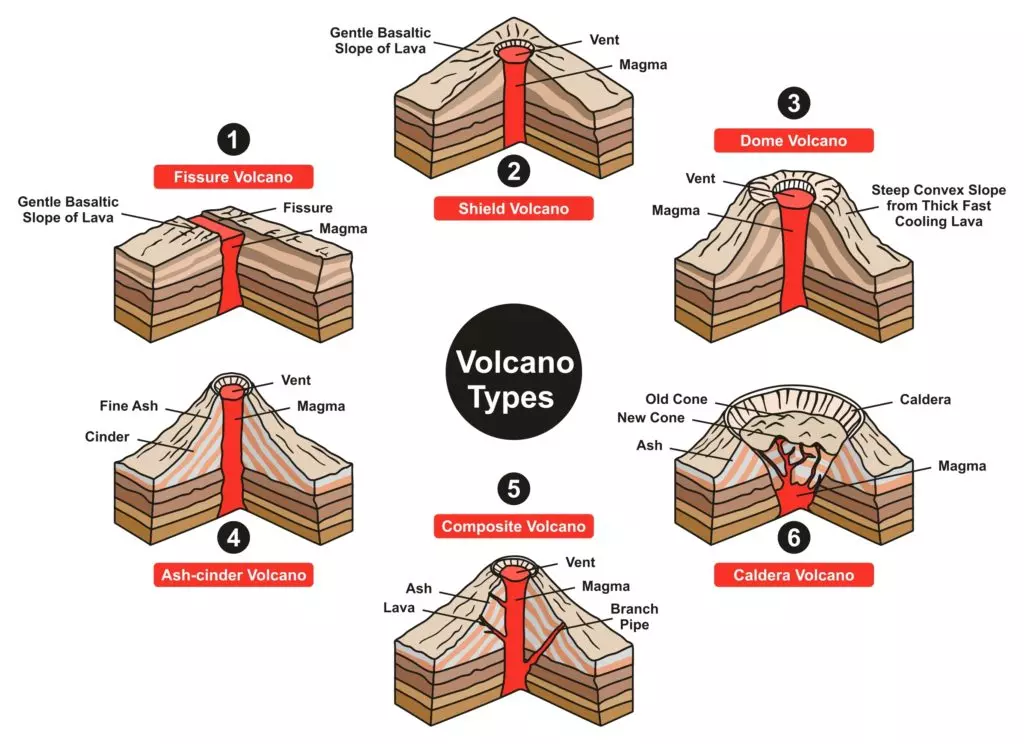
- Fissure volcano: formed by a linear opening in the continental or oceanic crust through which escapes fluid lava. We have, for example the oceanic ridge for this type of volcanoes.
- Shield volcano: the diameter is much greater than its height due to the fluidity of the lavas which can travel for kilometers before stopping. For example, the Mauna Loa in Hawaii is a shield volcano.
- Dome volcano: large volcanic dome formed by the accumulation of slow eruptions of highly viscous lava. The Puy de Dôme is an example of this kind of volcano.
- Volcanic cones (or cinder cones): it results from eruptions of mostly small pieces of scoria and pyroclastics (both resemble cinders, hence the name of this volcano type) that build up around the vent.
- Stratovolcanoes (composite volcanoes): the diameter is more balanced compared to its height due to the greater viscosity of the lavas; these are volcanoes with explosive eruptions. The conical mountain is composed of lava flows and other ejecta in alternate layers. For instance, the Mount Fuji in Japan is an example of this type of volcano.
- Caldera volcano: large depression due to the collapse of rocks above a magma chamber. The Yellowstone caldera is an example of the caldera.
- Maar: low-relief volcanic crater caused by a phreatomagmatic eruption ( explosion that occurs when groundwater comes into contact with hot lava or magma). A maar characteristically fills with water to form a relatively shallow crater lake which may also be called a maar.
Tectonic plates and volcanoes world map
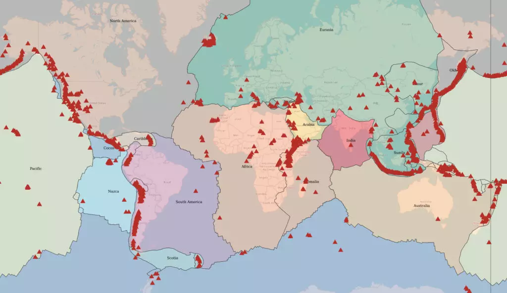
If you look to the volcanoes world map, you can see that most of them are linked to tectonic plates boundaries. Firstly, we will present the 2 types of volcanoes linked to the tectonic plates. Then we will see the last type of volcanoes which are not linked to the plate tectonics.
Divergent plate boundaries
At the ridge, the separation of two tectonic plates thins the lithosphere, causing a rise in mantle rocks. These, already very hot, start to melt partially due to decompression. This gives magma which infiltrates through normal faults. Between the two edges of the rift, traces of volcanic activity such as pillow lava (formed by the emission of fluid lava in cold water). Thus, these volcanic rocks constitute a part of the oceanic crust.
In the continental rifts, the same process occurs, except that the lava does not flow underwater and does not give pillow lava.
Convergent plate boundaries
When two tectonic plates overlap, the oceanic lithosphere, sliding under the other oceanic or continental lithosphere, plunges into the mantle and undergoes mineralogical transformations. The water contained in the plunging lithosphere then escapes and hydrates the mantle, causing its partial melting by lowering its melting point. So, this magma rises and crosses the overlapping lithosphere, creating volcanoes.
If the overlapping lithosphere is oceanic, an island volcanic arc will form, the volcanoes giving rise to islands. This is the case for the Aleutians and Japan.
If the overlapping lithosphere is continental, the volcanoes will be located on the continent, generally in a cordillera. This is the case of the Andean volcanoes or the Cascade range. These volcanoes are generally gray, explosive and dangerous volcanoes. This is due to their viscous lava because it is rich in silica, which has difficulty flowing; moreover, the magmas which rise are rich in dissolved gases (water and carbon dioxide), the sudden release of which can form fiery clouds. The “Pacific Ring of Fire” is made up almost entirely of this type of volcano.
Hot spot
It sometimes happens that volcanoes are located far from any lithospheric plate boundary. They are generally interpreted as hot spot volcanoes. The hot spots are plumes of magma coming from the depths of the mantle and piercing the lithospheric plates.
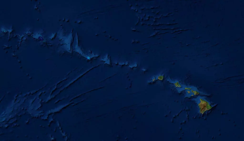
The hot spots being fixed, while the lithospheric plate moves on the mantle, volcanoes are created successively and align then, the most recent being the most active because at the base of the hot spot. When the hot spot emerges under an ocean, it will give birth to a series of aligned islands as is the case of the Hawaiian or Mascarene archipelago.
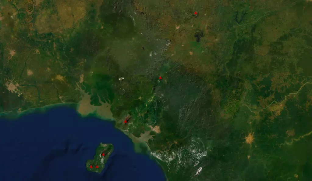
If the hot spot emerges under a continent, it will then give birth to a series of aligned volcanoes. This is the case of Mount Cameroon and its neighbors.
In exceptional cases, it happens that a hot spot opens out under a lithospheric plate boundary. In the case of Iceland, the effect of a hot spot combines with that of the mid-Atlantic ridge, thus giving rise to a huge stack of lava allowing the ridge to emerge. The Azores or Galápagos are other examples of hot spots opening out under a lithospheric plate boundary.
However, many intra-plate volcanoes do not occur on alignments to identify deep and permanent hot spots.
The Pacific Ring of Fire
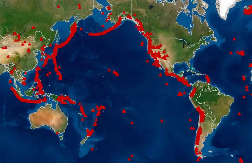
The Pacific Ring of Fire (also known as the Rim of Fire or the Circum-Pacific belt) designates the alignment of volcanoes that border the Pacific Ocean over most of its periphery, approximately 40,000 km (25,000 mi) .
This alignment of volcanoes, all located exclusively on the coasts or islands, coincides with a set of limits of tectonic plates and faults. These limits are also marked by the main ocean trenches on the planet.
Top 10 biggest volcanoes in the world by height
1. Mauna Kea, Hawaii
This volcano is 4,207 m above sea level, but with its part under water, it is 10,203 m (33,474 ft). It makes this volcano in total height even higher than the Mount Everest. This volcano is a hot spot in the pacific plate.
2. Mauna Loa
Secondly, we find another volcano of Hawaii, which is made of 5 volcanoes. This volcano is 9,170 m (30,085 ft) from the bottom of the sea level.
3. Haleakalā or East Maui Volcano
On the 3th place, we have another volcano of Hawaii. This volcano is 9,144 m (30,000 ft).
4. Teide
This volcano is located on the island of Tenerife. It has an altitude of 3,718 m (12,198 ft) above sea level. From the bottom of the sea level, it is 7,500 m (24,606 ft).
5. Piton des Neiges
It is the massive shield volcano on the Reunion. From the bottom of the ocean, it has a total elevation of 7,071 m (23,199 ft).
6. Ojos del Salado
This volcano is located in the Andes on the Argentina – Chile border. It is the highest active volcano in the world. It has an altitude of 6,893 m (22,615 ft).
7. Monte Pissis
This volcano is an extinct volcano located in Argentina and it has an elevation of 6,792 m (22,283 ft).
8. Nevado Tres Cruces
This volcano is also located in the Andes on the Argentina – Chile border. It has an elevation of 6,748 m (22,139 ft).
9. Llullaillaco
This volcano is also located on the border between Argentina and Chile. It has an elevation of 6,739 m (22,110 ft).
10. Tipas
Finally the last volcano of our list is also located in the Andes on the border between Argentina and Chile. It has an elevation of 6,670 m (21,880ft)