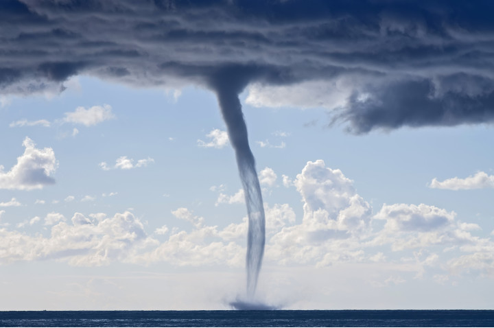
Tornadoes
A tornado (also called a twister) is an extreme meteorological event that can be very dangerous for populations and can cause a lot of damage. According to the World Meteorological Organization, tornadoes kill between 300 and 400 people each year and including 150 only in the United States. Indeed, some regions are more vulnerable and more exposed to tornadoes. But before explaining their distribution around the world, we need to understand how they formed.
Table of contents
- How are tornadoes formed
- What causes a tornado to stop?
- Categories of tornadoes (Enhanced Fujita scale)
- Types of tornadoes
- What looks like a tornado but isn’t?
- Where do tornadoes occur in the world?
- Tornado Alley
- Dixie Alley
- Hoosier Alley
- Carolina Alley
- The 10 most deadliest tornado in the world
How are tornadoes formed
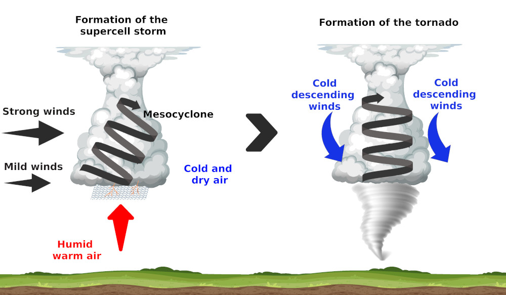
Tornadoes form only under very precise conditions. Most of the tornadoes form in a supercell thunderstorm. These storms are very powerful thunderstorms that form essentially in summer.
Indeed, the sun warms the ground, giving a warm and wet air parcel. This air that escape from the ground is warmer and so less dense. As a result the air parcel will rise.
The air parcel, by rising up, will meet a cold and dry air. The wet air parcel will condense and form a cumulus cloud. If the air above is cold and dry enough and they air that rise warm and wet enough, it will continue to raise until the tropopause to form a cumulonimbus. This cycle is the standard cycle of a thunderstorm, but we still don’t have a supercell.
To get a supercell thunderstorm, there needs to be a wind speed variation (more quickly with the altitude) or directions variation with the altitude. This effect is the so called wind shear. This will induce a horizontal rotation inside the cloud. This horizontal tube will be pushed to the vertical by the ascending air of the cumulonimbus. This gives finally an inclined rotating tube of air inside the cumulonimbus, which is called a mesocyclone. By then the full cloud starts to rotate, which by now can be called a supercell thunderstorm.
These supercell thunderstorms can stay active for hours with heavy rain, hailstone and thunders.
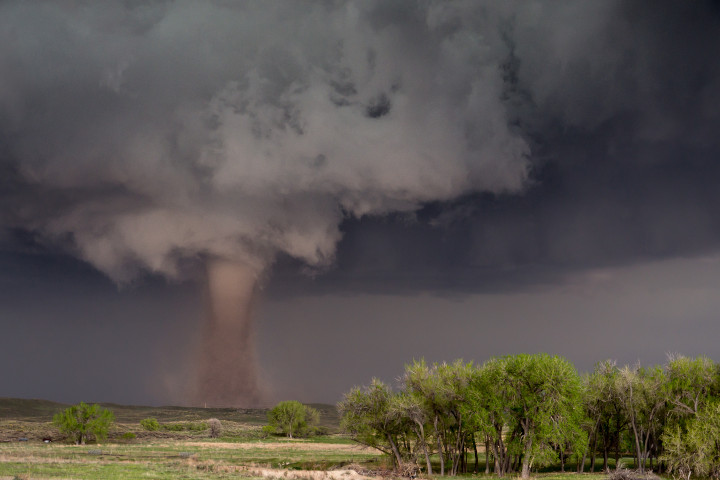
To get a tornado from these supercell thunderstorms, we need more powerful winds. Inside the cloud, the rain cools the air, which become more dense and they go down to the ground. These downward currents encircle the mesocyclone and force him to the vertical. A small cone, called tuba, form under the cumulonimbus. The winds accelerate until the ground surface and when the tuba touch the ground, we get a tornado with winds that can flow with a speed of 400km/h (250 mph).
Not every supercell thunderstorms produce tornadoes. Only around 20 percent of all supercell thunderstorms produce tornadoes.
What causes a tornado to stop?
The phenomenon is fading when the balance between rising and falling air is no longer maintained or when the tornado meets a relief.
Categories of tornadoes (Enhanced Fujita scale)
Tornadoes are categorized by order of their seriousness of the damage that they cause. The first scale used for this classification was the Fujita scale, also called the Fujita-Pearson Scale or F scale. This scale was established in 1971 by Ted Fujita and Allen Pearson.
It is important to note that this classification is not based directly on the wind speed, but rather on the damage caused by the tornado. The categories of tornadoes are determined afterwards the tornadoes is done.
The Fujita had originally 6 categories (from F0 to F5) which is add 7 theoretical categories never met en that go from F6 to F12.
Average wind speed in the tornado, 10 m altitude above flat ground, are given for indication (harder short time winds are possible). These wind speeds are indicative because no direct relation between wind speeds and damages have been done.
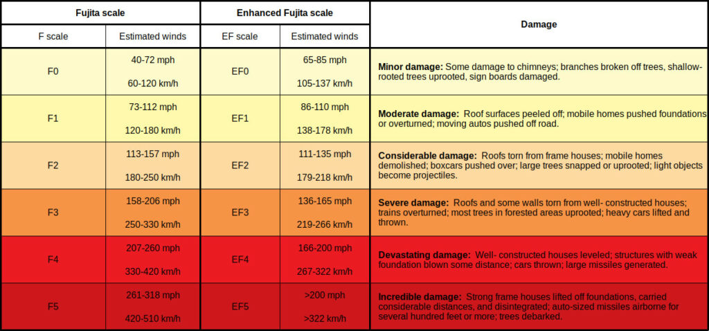
The Fujita scale had received some critics because it didn’t take into account some factors like the quality of the materials of the buildings, not enough indicators,… Because of this, an Enhanced Fujita scale has been released in 2007. This new scale has 28 indicators, which helps to take into account much more types of building and quality of buildings. It also uses an estimation of speeds obtained by meteorological radars. This new scale also helps to categorize tornado in every part of the world more accurately.
The 2 scales are similar and have the same categories. Only the way to determine the intensity of the damage is different and also the speeds of the winds to produce these damages are different. Indeed, the meteorologist had the impression that the winds in the first scale were too high for the damage caused. Indeed, the total devastation of the F5 was caused following the scale by winds of 420 km/h (261 mph) and the new scale determine the speed necessary to be 322 km/h (200 mph).
Types of tornadoes
Tornadoes are usually distinguished in supercell and non-supercell, with therein different subtypes.
Supercell tornadoes
These tornadoes are the most common and often the most dangerous. In function of their shape and size, we can distinguish different subtypes. Tornadoes that lived for a certain time may transit from one type to another as it changes in size and shape during its life.
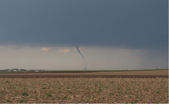
Rope tornado
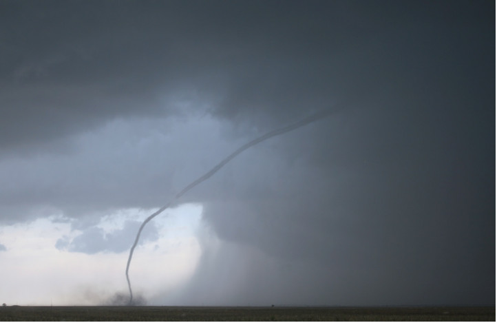
They have the shape of a rope and they are the most common types and the smallest tornadoes. Most tornadoes begin and end their life as a rope tornado. Some also stay in this type and only last a few minutes.
Although they are the smallest of all the tornado, they are still dangerous and some of them get more intense as they narrow and tighten.
Cone tornado
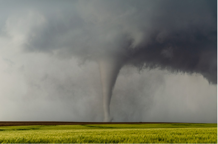
This type of tornado has the “typical” conical shape of a tornado with a wider base than the robe tornadoes and they are much wider on the side touching the thunderstorm.
The cone tornadoes have a wider footprint on the ground and so they can leave a larger trail of destruction.
Stovepipe or cylinder tornado
Theses tornadoes are similar to the cone tornado, but the width on the ground is similar the width at the base of the thunderstorm.
Wedge tornado
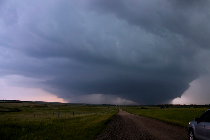
Wedge tornadoes are wider than they are tall (at least as wide as their height cloud-ground). The width is around 1 km (0.6 mile) and more. Wedge tornadoes are usually classified EF-3 or more. These tornadoes leave huge destruction trails.
Satellite tornado
A satellite tornado is a tornado located around a main primary tornado and is interacting with the same mesocyclone. Satellite tornadoes are apart from the primary tornado and so they are different then multiple vortex tornadoes. These types of tornadoes are not common. The satellite tornado and the primary tornado are called a couplets.
Multiple vortex tornado
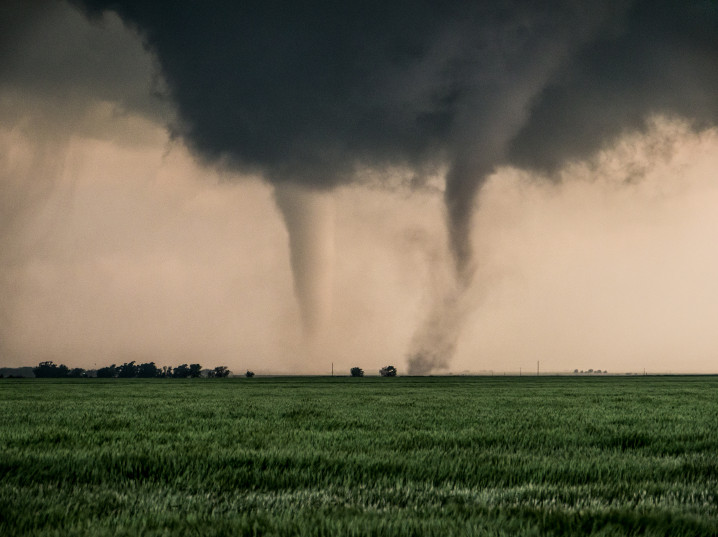
A multiple vortex tornado is a tornado with several vortices (called subvortices or suction vortices) circling around or inside and as a part of the main vortex. The subvortex can produce localized area of higher winds than the main circulation.
This type of tornado is difficult to observe because of the dirt and debris carried upward. They are visible when the tornado form or when the condensation and the debris are balanced. They form usually in the lower part of the tornado vortex where the tornado makes contact with the surface.
Non-supercell tornadoes
Non-supercell tornadoes are not linked with a storm rotation and are rather created by a vertically spinning parcel of air occurring near the ground. These tornadoes cause less damages than the supercell tornadoes.
Landspout
Landspout is a narrow rope-like condensation funnel that form while the thunderstorm cloud is still growing. They are formed by a vertically spinning parcel of air occurring near the ground. These tornadoes are weaker than the one caused by supercell, but they can still cause serious damage (until EF2).
Waterspout
Waterspout are like landspout, but they form above water. A few of the waterspout are stronger and can be caused by a supercell thunderstorm. But the big majorities are non-supercell tornadoes. Sometimes they can hit the ground and then become a land tornadoes.
What looks like a tornado but isn’t?
Some phenomenon looks like tornadoes because they have the same rotation characteristics, but they are not considered like tornadoes. Indeed a tornado needs to be linked with a storm event. Below is a list of events that looks like tornadoes, but that are not.
Gustnado
Gustnado (or gust front tornado) are small vertical swirl associate with a gust front of a storm system. They look like real tornadoes, but they are not connected to the base of the cloud and so they are not considered as tornadoes.
Dust devil

Dust devil are also composed of a vertical swirling column of dust, which make them look like a tornado, but it is not a tornado because there is no link with a cloud. They form under clear skies and hot day. They are formed by a strong convective updraft from the warm air on the ground surface and low level wind shear.
They have diameters from 1 centimeter to 10 meters and a vertical extension that goes from a few meters to more than 1000 meters.
They last only for a few minutes and they can be as strong as the weakest tornadoes. So they can cause minor damages.
Dust devil is the common name, but it has local names like willy-willies in Australia
Fire whirls
Fire whirls are not common and usually very weak, but it can be as strong as an EF3. They are associated with wildfires and the large difference of temperature between the fire on the ground and the cooler air in altitude causes the air to rise. The rising air and the wind circulation above the ground create the rotation.
Steam devils
Steam devils are very rare to observe. They are rotating updraft of steam or smoke. They are not linked with high wind speeds (the rotation is at a speed of only a few rotations per minutes). They form mostly from smoke from power plants, but it can also form above hot springs, deserts, water areas, …
Where do tornadoes occur in the world?
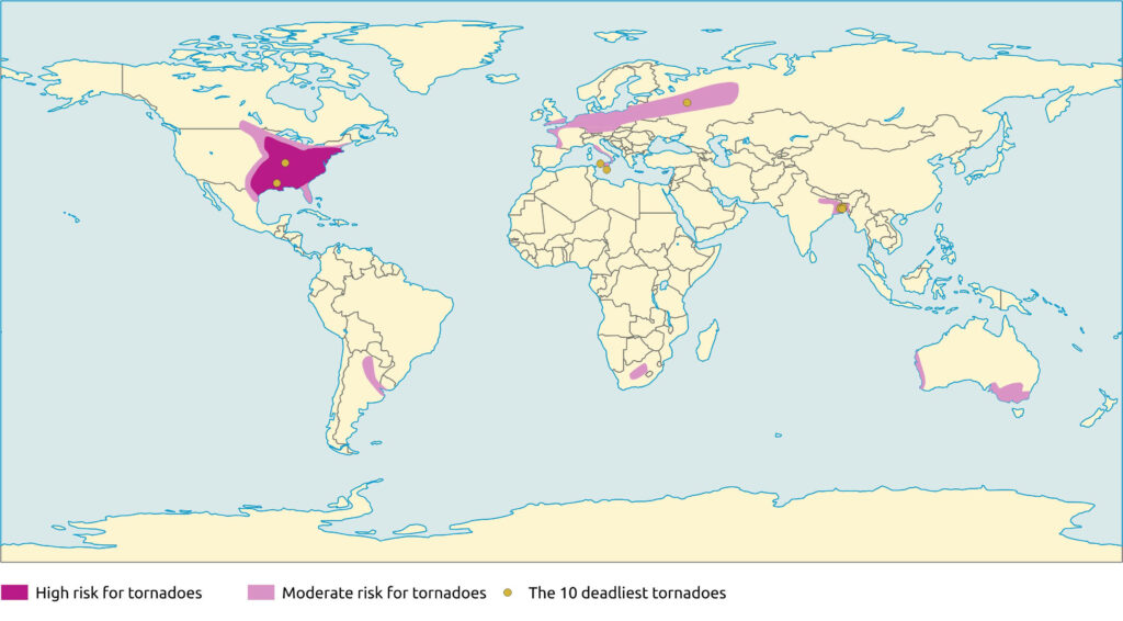
Tornadoes occur in different regions of the world, but some of them are more hits.
The United States are hit by the highest number of tornadoes and they are of very high intensity. Between 800 and 1300 tornadoes are registered in the US each year and around 20 of them are from the EF4 or EF5 category.
| Rank | States | Annual average number of tornadoes by 10,000 sq miles (25 900 km²) |
|---|---|---|
| 1 | Florida | 12.2 |
| 2 | Kansas | 11.7 |
| 3 | Maryland | 9.9 |
| 4 | South Caroline | 9.8 |
| 5 | Illinois | 9.7 |
| 6 | Mississippi | 9.2 |
| 7 | Iowa | 9.1 |
| 8 | Oklahoma | 9 |
| 9 | Alabama | 8.6 |
| 10 | Lousiana | 8.5 |
| 11 | Arkansas | 7.5 |
| 12 | Nebraska | 7.4 |
| 13 | Missouri | 6.5 |
| 14 | North Caroline | 6.4 |
| 15 | Tennessee | 6.2 |
| 16 | Texas | 5.9 |
| 17 | Minnesota | 5.7 |
The highest density of tornadoes in the world is located in Florida and they are mostly of low intensity in this region.
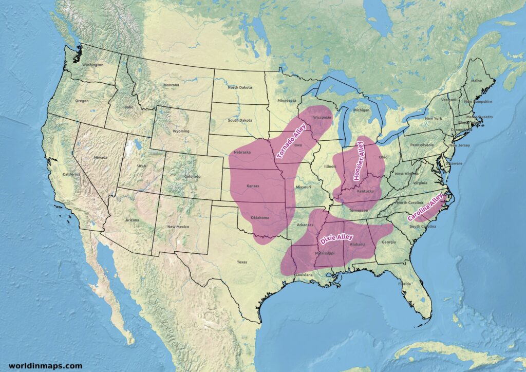
But the most active area is the Basin of the Mississippi River and the Great Plains in the United States. The tornadoes are there generally very powerful. It is for this reason that the states of Texas, Oklahoma, Kansas, Nebraska, Arkansas, Missouri, Iowa and Wisconsin were given the name Tornado Alley witch one third of the Tornadoes of the United States. The next chapters will detail the four main United States Alleys (Tornado Alley, Dixie Alley, Hosier Alley and the Caroline Alley).
Other parts of the world are also hit by tornadoes. In Africa, they can be found in South Africa.
In South America they happen in some regions of Argentina, Paraguay and the south part of Brazil.
In Europe, they are more common in the plain of northern Europe, especially in Germany and Poland. But in terms of density it is in the Netherlands that they are the highest with 20 tornadoes per year and a density of 0,00048 per square kilometer. Then it is followed by the United Kingdom and its 33 tornadoes. Mostly they are from very low intensity and they are mostly EF1. The European Tornado Alley is located between the Benelux (Belgium, Netherlands and Luxembourg) and Germany.
Tornadoes also happen in Australia and New Zealand.
Finally, they are also very common in the Delta of the Gange in Bangladesh. They are as often and strong as in the United States and count more dead each year than in the United States. But there is less mediatization about them.
Urban and rural areas are both touched by tornadoes. Some big cities report numerous tornadoes in their metropolitan area like Miami, Oklahoma City, Dallas, Dhaka, …
The reporting number of tornadoes is strongly depending on the distribution of the world population. For example, Canada report 80 to 100 tornadoes each year, but big areas of Canada are sparsely populated and the real number is probably much higher.
Tornado Alley
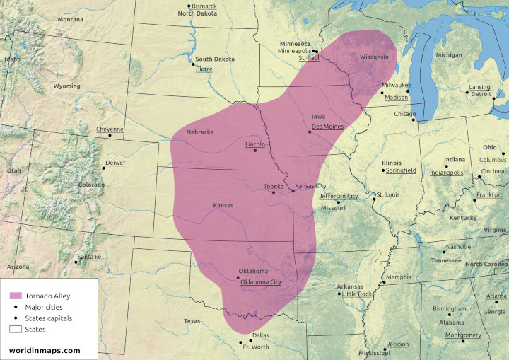
The Tornado Alley refers to a central region of the United States, covering several states or parts of states, where tornadoes are frequent.
There is not exact delimitation of the Tornado Alley, and the boundaries depends on the statistics used.
The Tornado Alley totally include the Oklahoma, the Kansas and the Iowa states. It covers also the northeast of the Texas, the northwest of the Arkansas, the west of the Missouri, the east of the Nebraska, a little part of the south of the South Dakota, the southeast of the Minnesota, a little part on the northwest of the Illinois and finally the central part and the southwest of the Wisconsin.
Although tornadoes occur in every region of the United States, they are much more frequent in this region located in the great plain, between the Rocky Mountains and the Appalaches where the condition for tornadoes are optimal.
Indeed, the Tornado Alley is located at the meeting of the continental cold air parcels coming from the Canadian Prairies, with the dry and hot air from the desert of Sonora, the hot and wet air coming from the Gulf of Mexico and finally with high variation of winds with altitude because of the presence of a Jet Stream.
Tornadoes can occur all the year around, but their frequency varies during the tornado season. Indeed the Tornado Alley trend to switch to the north with the warming of the temperature, from spring to summer, and on the opposite to the south when the temperature become colder in autumn.
The consequence of this Tornado Alley is that in its center part the building standards are more strict. With for example reinforced roof, tornado shelters, …
Dixie Alley
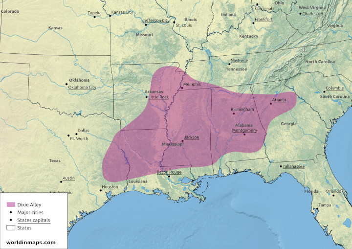
The Dixie Alley is the name given to a region of the United States where a very high number of tornadoes happen each year and of very high intensities.
The Dixie Alley includes much of the region of the lower Mississippi. It includes the following states: Mississippi, Louisiana, the east of Texas, the east of Arkansas, the southwest of Tennessee, the Alabama and the north of Georgia.
This region is under favorable condition to produce tornadoes, which explain their high numbers. Indeed, it has the same condition as the Tornado Alley. The region is under the cold continental air coming from the north and the hot and wet air from the Gulf of Mexico. This creates a very unstable condition. The cold air flowing to the southeast uplift the hot air. These hot air parcels continue their uplift and the humidity condense to create storms with very height vertical extension, the so called cumulonimbus clouds.
From autumn to spring, the region is under winds that are from different directions and intensity with the altitude, because of the presence of a Jet Stream. This wind shear will create the supercell thunderstorms that will be able to give tornadoes. In the summer the Jet Stream moves to the north.
The pic of intensity of tornadoes in this region is around May and with a second wave in October and November. But tornadoes can be seen all the year around. Which make them very dangerous in this region because a tornado can still happen outside the tornado season, when people’s vigilance is lower.
Indeed, this region produces less tornadoes then the Tornado Alley, but there is more dead in this region each year than in the Tornado Alley. Another reason is that tornadoes are very powerful in this region and that they travel long distances in an area of high population density. According to the National Centers for Environmental Information, Texas, Alabama, Mississippi, Arkansas and Tennessee are States on top of the ranking of the number of deaths from tornadoes between 1950 and 2006. Another factor is that the supercell thunderstorms also happen during the night, which can surprise people in their sleep. Finally the storms produce very high precipitation, which make the tornado difficult to see.
Hoosier Alley
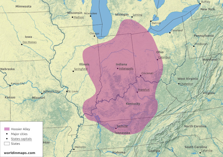
The Hoosier Alley is the third most active area in the United States for tornadoes. This alley is centered on the Indiana and includes the east of Illinois, the Kentucky, the north of Tennessee and the west of Ohio. Like for the Dixie Alley these storms are fast moving and with a lot of rain, which make the tornadoes difficult to see.
Carolina Alley
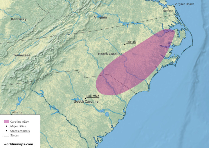
The Carolina Alley is the fourth most active area for tornadoes in the Unites states. This alley is located in North Carolina and the northeastern of South Carolina.This alley is also concerned with fast moving storm and heavy rains.
The 10 deadliest tornado in the world
| Rank | Name / location | Country | Date | Deaths |
|---|---|---|---|---|
| 1 | Daultipur and Saturia | Bangladesh | 26 April 1989 | 1300 |
| 2 | Tri-State Tornado | US | 18 March 1925 | 695 |
| 3 | Manikganj, Singair and Nawabganj | Bangladesh | 17 April 1973 | 681 |
| 4 | 1969 East Pakistan Tornado | Bangladesh | 14 April 1969 | 660 |
| 5 | Grand Harbour at Valletta | Malta | 23 September 1551 | 600 |
| 6 | Magura and Narail Districts | Bangladesh | 11 April 1964 | 500 |
| 6 | Sicily | Italy | 8 December 1851 | 500 |
| 6 | Madaripur and Shibchar | Bangladesh | 1 April 1977 | 500 |
| 9 | Belyanitsky, Ivanovo, and Balino | USSR | 9 June 1984 | 400 |
| 10 | Natchez, MS | US | 6 May 1840 | 317 |
Foehn winds
Explore the fascinating world of Foehn winds, a captivating meteorological phenomenon that unfolds when prevailing winds encounter mountain ranges. These winds, also known as Föhn winds, create a unique climatic impact, resulting in dry and warm down-slope winds on the lee side of the mountains. Uncover the origins of the term “Foehn” from Swiss German and Latin influences, and delve into the intricate processes behind their formation. Discover how Foehn winds can influence precipitation, temperature, and cloud formations on the upwind slopes, while bringing warm, arid conditions on the downwind side. Journey through the diverse consequences of Foehn winds, from transforming landscapes and fostering deserts to their role in forest fires and sudden snowmelt. Join us as we unravel the intricacies of this meteorological marvel and uncover its intriguing effects on both nature and human well-being.
Table of contents
- Definition
- Where does the word Foehn come from?
- How do foehn winds form?
- Consequences of Foehn wind?
- Where are Foehn winds found?
- Foehn winds in California – Oregon and desert
- Foehn and Chinook winds?
- Foehn wind and other names?
- Foehn wind health effects
Definition
Foehn winds (also spelled Föhn winds) are meteorological phenomenon that happens when prevailing wind meets a mountain range. The result of this interaction is a dry and warm down-slope wind on the downwind side of the mountain range.
Where does the word Foehn come from?
The name Foehn come from the Swiss German Föhn which come from the Latin favōnius, a mild west wind. After it was adopted by the German Alpine dialects and designated a strong, dry and warm wind of the German Alps. This wind is where the phenomenon was first studied.
How do foehn winds form?

When the wind meets a mountain more or less perpendicularly, it follows the relief and rises. The atmospheric pressure decreases with the altitude and as a result the temperature of the air decreases by adiabatic expansion following the dry adiabatic lapse rate.
If the humidity is high enough at the beginning, since colder air can hold less water vapor, moisture will condense on the altitude point where saturation is reached (condensation level). So cloud will form and precipitation as rain and/or snow will occurs on the mountain’s upwind slopes.
The change of state from vapor to liquid water heats the air and partially counter the cooling of the air while it rises. Indeed, solar radiation, which provided heat and allowed the water to evaporate at ground level, is returned to the air by latent heat. The rate of decrease in the temperature of the air parcel will therefore be from this moment according to the saturated adiabatic lapse rate, as long as there is steam to condense. The rate of temperature variation for the dry air (dry adiabatic lapse rate) is around 10°C /km (around 5.5 °F per 1,000 ft) and of around 6°C / km (around 3.3°F per 1,000 ft) for saturated air (moist adiabatic lapse rate).
The Foehn effect don’t always produce rain, snow or even thick clouds on the upwind side. When there is no precipitation on the upwind side, and that if any clouds they have evaporated, then the temperature between the 2 sides of the mountain range are the same for the same altitude.
Consequences of Foehn wind?
They can be responsible for a difference of climate between each side of the mountain range. Indeed, when the upwind side is affected by rain and clouds, the down slope is affected by a dry and warm wind. This can be benefit, for example for vineyards, but this can also lead to desert on the down slope side of the mountain range. It can also be problematic for forest fire like it is the case in California.
Because of the strong wind, it can also create damage on the buildings and infrastructure.
Finally, the Foehn wind is also responsible for the sudden smelting of snow in regions where they are active.
Where are Foehn winds found?
These winds are found everywhere in the world where the prevailing wind meets a mountain range more or less perpendicularly. This phenomenon is global but, because the general circulation of the wind is along the parallels, it can be found at every mountain range oriented North – South.
Foehn winds in California – Oregon and desert

Like explain in a previous chapter, Foehn winds can be responsible for desertification. One example of this is the Sequoias and the Petrified forest on the United States west coast.
Until the Eocene the Rocky mountains and the Sierra Nevada mountain ranges were not so high and the Foehn had no effect on the lee (downwind side) because the air parcel didn’t go high enough to cross the condensation level. So the air parcel was following the dry adiabatic lapse rate on both sides of the mountain range and the vegetation was luxurious on both sides.
Then started the uplift of the Rocky mountains and the Sierra Nevada mountains. As a result the mountain range crosses the condensation level, and the upwind side began to be under clouds and precipitation condition. Because of this lose of water, the dry adiabatic lapse rate is reached more early on the downwind side. As a result the temperature on the lee is higher for the same altitude on the upwind side.
Like explain in the previous chapter the general circulation of the wind is along the parallels and so we can find the same type of desert on mountain range oriented North – South.

We have, for example, the Norwester (local Foehn wind name) in New Zealand that cause desert condition in the Marlborough region.

Another example of this is the Zonda (local name for the Foehn wind) in Chili and Argentina.
Foehn and Chinook winds?
Chinook winds are a local name for Foehn winds and it is used for the winds on the east sides of the Rocky Mountains in North America.
Foehn wind and other names?

We saw in the previous chapter that Chinook winds are a local name for Foehn winds, but there are other local names for this type of wind. Here is a list of some of them:
| Continent | Name | Location |
|---|---|---|
| Africa | Berg wind | South Africa |
| Asia | Loo | Indo-Gangetic Plain |
| Warm Braw | Schouten Islands north of West Papua, Indonesia | |
| Europe | Foehn | Alps |
| Fogony | Catalan Pyrenees | |
| Halny | Carpathian Mountains | |
| Helm | Cumbria, England | |
| North America | Chinook | East of the Rocky Mountains in Canada and the United States |
| Santa Ana | Southern California | |
| Oceania | The Norwester | East coast of New Zealand |
| Sout America | Puelche | Eastern wind that occurs in south-central Chile |
| Zonda | Eastern slope of the Andes in Argentina |
Foehn wind health effects
Following local believing, Foehn wind is linked with increased mental illness and states like aggressiveness, depression, suicide, anxiety, headaches, psychosis, …
Some modern studies are studying these believing and have shown an increase in suicides and accidents during episodes of Foehn.
Types of clouds and their characteristics
Clouds are in meteorology visible masses made of a big quantity of liquid droplets and /or frozen crystals suspended in the atmosphere. These clouds are formed by very small droplets of water and / or ice crystals (2 to 200 microns in diameter) obtained by the condensation of water vapor from the atmosphere around tiny particles (dusts, aerosols, …) called condensation nuclei.
The aspect of a cloud is characterized by its form, texture, opacity and colors. These parameters vary in function of the constituent of the cloud and the atmospheric conditions.
Table of contents
- How are clouds classified
- The 10 basic cloud types (genera)
- The 14 species of clouds
- The 9 varieties of clouds
How are clouds classified
The international classification uses the families, genera, species and varieties. This is similar to the classifications use for plants and animals and like these classifications, Latin names are used.
The nomenclature is based on 4 Latin names depending on the characteristics of the cloud.
| Names | Characteristics |
|---|---|
| Cumulus | rounded form |
| Cirrus | fibrous form |
| Stratus | layer without a specific form |
| Nimbus | accompanied by rain |
These names can be associated to define the different clouds of the classification.
In total the World Meteorological organization recognized currently 10 genera that are group in 4 families. Theses families correspond to 3 different altitudes intervals of the troposphere and 1 family for the clouds with high vertical development across the 3 different layers.
The 10 basic cloud types (genera)

| Family | Genera (name and symbol) |
|---|---|
| High clouds (ice) polar regions: 3 km to 8 km (10,000 to 25,000 ft)temperate regions: 5 km to 13 km (16,500 ft to 40,000 ft)tropical regions: 6 km to 18 km (20,000 ft to 60,000 ft) | Cirrus (Ci) |
| Cirrocumulus (Cc) | |
| Cirrostratus (Cs) | |
| Middle level clouds (liquid water / ice) polar regions: ~2 km to 5 km (6,500 ft to 16,500 ft)temperate regions: ~2 km to 9km (6,500 ft to 30,000ft)tropical regions: ~2 km to 12 km (6,500 ft to 40,000 ft) | Altocumulus |
| Altostratus (As) | |
| Nimbostratus (Ns) | |
| Low clouds 0 km to 2 km (0 ft to 6,500 ft) | Stratocumulus (Sc) |
| Stratus (St) | |
| Towering vertical polar regions: 0.5 km to 8km (1,650 ft to 25,000 ft)temperate regions: 0.5 km to 13 km (1,650 ft to 40,000 ft)tropical regions: 0.5 km to 18 km (1,650 ft to 60,000 ft) | Cumulus (Cu) |
| Cumulonimbus (Cb) |
Cirrus (Ci)

These are fibrous wisps of delicate white ice crystal clouds. They can be found in large fields or in narrow white bands. Sightly opaque, sunlight can pass through it. These clouds are pink or red after the sunset. These clouds don’t produce precipitation.
Cirrostratus (Cs)

These clouds are made of ice crystal and it forms a translucent whitish veil completely or partially covering the sky. These clouds are often accompanied by a halo phenomenon. This type of cloud also don’t produce precipitation, but it announces the arrival of a depression.
Cirrocumulus (Cc)

These clouds are rarely observed. They are shaped like a cotton flower and very small. They are composed of ice crystals or supercooled water droplets. These clouds are non-precipitating, but they can indicate the arrival of a front.
Altostratus (As)

These clouds are stratifom and they are present in layers in which the limits are difficult to define. They form a broad gray, slightly streaked or fibrous layer. They let light diffuse without a visible shadow on the ground. They have a thickness of 500 m to 3 000 m (1,650 ft to 10,000 ft). They are composed of water droplets, but it may be mixed with ice crystals at higher altitudes. Widespread opaque altostratus can produce light continuous or intermittent precipitation (rain or snow). These clouds are relative to a stable air.
Altocumulus (Ac)

These clouds are in the form of lamellae, pebbles, rolls with a sometimes partially fibrous or fuzzy appearance. They may or may not be welded. They are white and / or gray and they appear as a bank, in a sheet or in a layer. These clouds usually have their own shadow, which helps distinguish them from cirrocumulus clouds.
Stratus (St)

These clouds are characteristic grayish in color and have a fairly uniform appearance. They are sometimes made up of separate elements with a jagged appearance. They are often accompanied by a hazy atmosphere. They are also likely to give off drizzle (precipitation of very fine droplets of water or granulated snow (diameter less than one millimeter)). This type of cloud can result from nighttime cooling, the influx of humid air from a lake, sea or ocean, evaporation above a body of water or after heavy rain.
Stratocumulus (Sc)

This type of cloud appears as a large, dark, rounded mass. Individually, each cloud is bigger than an altocumulus cloud. They are usually present in groups, lines or waves. This type of cloud has a convective origin, but the vertical extension is immediately limited by the stability of the upper layer.
Cumulus (Cu)

This type of cloud is loose, normally dense, and budding in appearance (cauliflower-shaped) with a small vertical extension. This type of cloud occurs during convection following an adiabatic expansion. They can form in many types of situation, but often following the passage of a disturbance (the cold front moves away and the sun becomes visible again, which causes the ground to warm).
Cumulonimbus (Cb)

This type of cloud is dense with a very high vertical extension (the highest). It is of convective origin. The top has the shape of an anvil. This cloud is the source of thunderstorms and it generally develops as a cold front approaches.
Nimbostratus (Ns)

This cloud is stratiform with a significant vertical extension. It is often made up of several layered layers without a defined shape and dark gray in color. It also completely hides the sun. It produces low to moderate precipitation, but over large areas.
The 14 species of clouds
The 10 genera of clouds are the top classification, but most of the genera are subdivided into species due to the particularity in shape. A species can belong to more than one genera of cloud. One genera can have more than one species and some genera have no species. The species are mutually exclusive, in other word a cloud can be assigned to only one species.
| Species | Description | Genera |
|---|---|---|
| Fibratus | Detached clouds or a fine veil consisting of almost straight or more or less irregularly curved filaments and they do not end in hooks or tufts. | Cirrus and cirrostratus |
| Uncinus | Cirrus usually comma-shaped terminating in its upper part in a hook or tuft and the upper end of which is not in the form of a rounded protuberance. | Cirrus |
| Spissatus | Cirrus clouds thick enough to be gray when viewed near the sun. | Cirrus |
| Castellanus | Clouds which present in their upper part protuberances in the form of towers and which give them a crenellated appearance. The towers come from the same base and they are arranged in a line. | Cirrus, cirrocumulus, altocumulus and stratocumulus |
| Flocus | Each cloud is a tuft of cumuliform appearance, the base of which is more or less jagged and which is often accompanied by virga (observable streak or shaft of precipitation falling from a cloud that evaporates or sublimates before reaching the ground). | Cirrus, cirrocumulus and altocumulus |
| Stratiformis | Clouds that extend in a large sheet or horizontal layer. | Stratocumulus, altocumulus and sometimes cirrocumulus |
| Nebulosus | Clouds in the form of a veil or layer, with no distinct detail. | Stratus and cirrostratus |
| Lenticularis | Lentil or almond shaped clouds, often elongated and with a well-defined perimeter shown by an iridescence. | Stratocumulus, altocumulus and cirrocumulus |
| Fractus | Clouds in the form of irregular rags with a distinctly jagged appearance. | Stratus and cumulus |
| Humilis | Cumulus of weak vertical extension. | Cumulus |
| Mediocris | Cumulus of average vertical extension and whose top shows small protrusions | Cumulus |
| Congestus | Cumulus of great vertical extension, the upper part of which resembles a cauliflower | Cumulus |
| Calvus | Cumulonimbus whose summit protuberances begins to lose their cumuliform appearance, but in which we can’t distinguish from cirriform parts. | Cumulonimbus |
| Capillatus | Cumulonimbus characterized by the presence at its summit of cirriform parts fibrous or striated, anvil-shaped, of plume or a large mass of more or less messy hair. It is often accompanied by a downpour or a thunderstorm. | Cumulonimbus |
The 9 varieties of clouds
We have finally the classification following to the 9 varieties of clouds. The varieties are function of the arrangements of the elements and the degree of transparency of the genera. The varieties aren’t mutually exclusive, in other word a cloud can be of different varieties. Only the varieties translucidus and opacus are mutually exclusive. It is important to note that clouds don’t have necessary to belong to one or several varieties.
| Varieties | Description |
|---|---|
| Intortus | Cirrus with irregularly curved and often twisted filaments. |
| Vertebratus | Mainly cirrus clouds arranged in the shape of vertebrae, ribs or having the appearance of the skeleton of a fish. |
| Undulatus | Clouds in the shape of waves and whose elements are sometimes separated, sometimes juxtaposed. |
| Radiatus | Clouds in parallel bands that seem to converge towards a point on the horizon |
| Lacunosus | Layer or cluster in which we find circular orifices equally distributed or clusters resembling a honeycomb. |
| Duplicatus | Multilayer (at different heights) of the same type of cloud. |
| Translucidus | Layer or cluster of fairly large horizontal dimension that allows to see the sun or the moon |
| Perlucidus | Quite large layer or cluster with distinct gaps, but sometimes rather small, and which let see the sun, the moon, the sky or other clouds. |
| Opacus | Large layer or cluster thick enough to mask the sun or the moon. |