Polders
Polders are land reclaimed from water by population and it is most specifically associated with the Netherlands. Indeed, they have acquired through the century a very broad knowledge in this domain. Before we start to show how important they are for the Netherlands, we need to understand what they are and how they are made.
Table of contents
- What is a polder?
- How are polders made?
- Where are polders found?
- Polders in Bangladesh
- Polders in the Netherlands
- Why are Polders important to the Netherlands?
- Polders and dikes in the Netherlands
- The Delta Works
What is a polder?
A polder is an artificial tract of land reclaimed from water from marshes, estuaries, lakes or coastal areas. Most often the level of the tract of land is lower than that of the sea.
How are polders made?

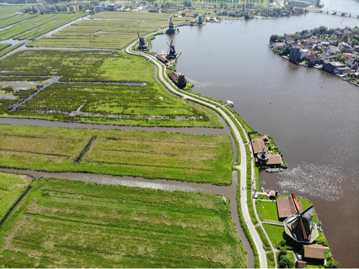
The surface to be developed is first surrounded by dikes. The water trapped between the dikes is then pumped. This was in the past operated by windmills equipped with a worm screw to raise the water to the sea, river or a channel. When this channel is also lower than the sea the water of the channel is also pumped into the sea with a windmill equipped with a worm screw. At the 19th century, these windmills were replaced by steam machines and by electrical and diesel motors in the 20th century.
The pumping of the water is not sufficient. To make the ground more dry, some plants, like reeds, are planted to dry up the ground.
To avoid the flooding of the polders by rain, a network of channels is built in the polders to drain all this water.
After the polder is built, the pump continues to work daily.
Where are polders found?
Polders are associate with Belgium and more notably with the Nederlands because a a substantial part of their area has been reclaimed from the sea over the centuries. But they are also found in Bangladesh, Canada, China, Denmark, Finland, France, Germany, Guyana, India, Ireland, Italy, Lithuania, Poland, Slovenia, South Korea, Spain, United Kingdom and United States.
Polders in Bangladesh
Bangladesh has 123 polders that are distributed along the sea (49 polders) and along the numerous distributaries of the Ganges – Brahmaputra – Meghna Rivers delta. These polders are recently built (in the 1960s) to protect the coast from tidal flooding and to reduce the salinity incursion for the agriculture.
Polders in the Netherlands
The Netherlands is frequently associated with polders because of their use across the centuries and their knowledge they have developed in this domain.

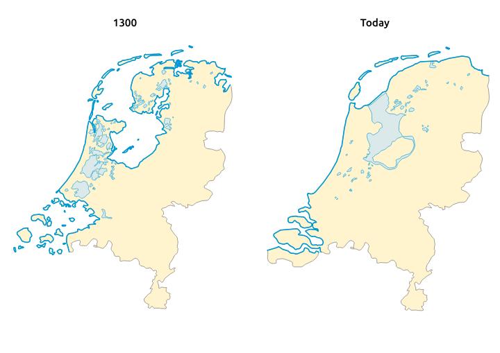
The Netherlands has started their conquest on land since the 13th century. 3 big periods of works can be distinguished. Between the 13th century and the 18th century, they have worked in the south and north of the country. Between the 18th century and all the 19th century the works where concentrated on the west of the country. And finally in the 21st century, they decided to build a full new province in the Zuiderzee, the Flevoland.
Why are polders important to the Netherlands?
The area of the Netherlands is 41 526 km², with 7 150 km² of polders, which represent 17% of the territories. In the beginning with the windmills, the soils were not dry enough for the agriculture and the polders where only use for breeding. After 1850 and the use of new technologies they managed to have the groundwater always at more than 1 m below the ground level of the polder which have allowed agriculture and the building of houses. Nowadays 60 % of the population the Netherlands lives on polders.
Polders and dikes in the Netherlands

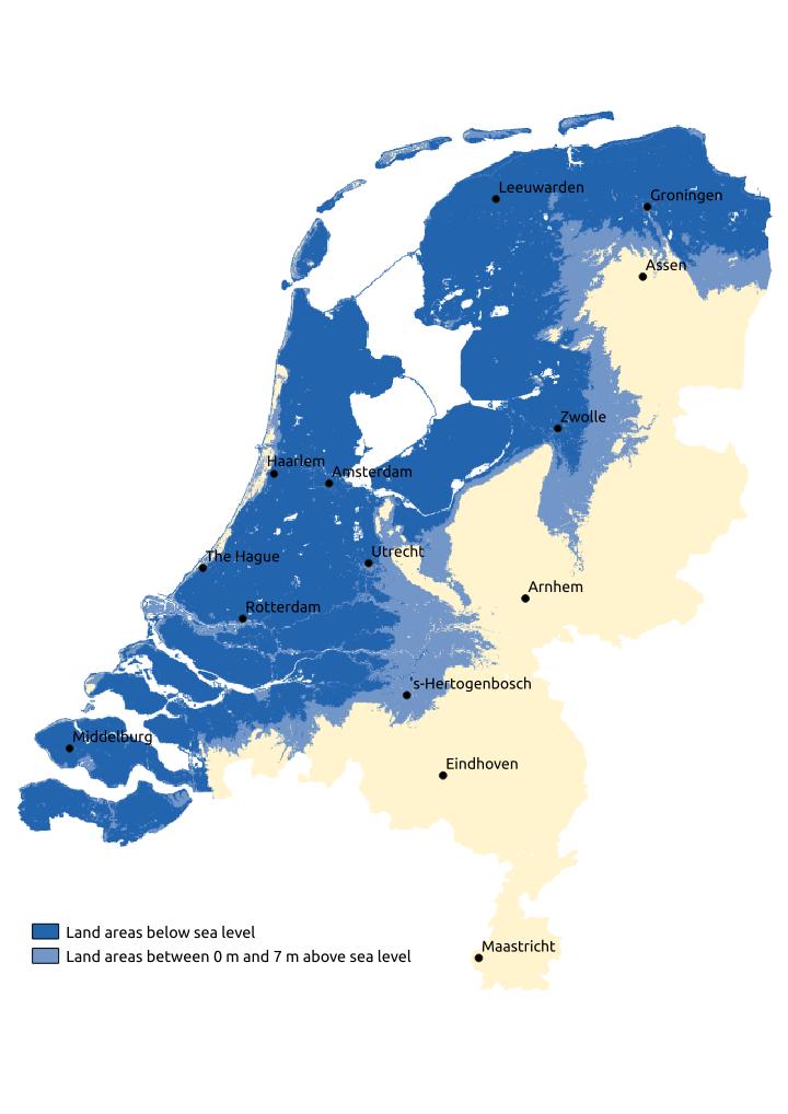
With this conquest over the sea a total of around 25% of the Netherlands are below the water level with a maximum of -6.76 m below the sea level, which is maximum for Europe. To protect these lands there are sand dunes all along the coastline. But these are not sufficient and dikes had to be built. Without these dikes, in times of high tide water would invade the land.
Another danger comes also from the rivers that have difficulties to flow down to the seashore because of the flatness of the Netherlands. If there where no dikes around these rivers, the water of the rivers will also invade the land.
Without all these infrastructures, more than the half of the country would be subject to flooding.
The Delta Works

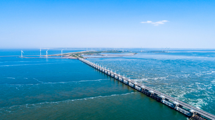
The Delta is a region of the south of the Netherlands, where the Rhine, Meuse and Scheldt flows into the North Sea. For a long period this region was very vulnerable because the sea could flood into the lands by using these 3 rivers like it has happened in 1953 and cause the death of 1800 persons. To avoid this to happen again, all the dikes were heightened to resist to a tide of 5m. But there was still 700 km of dikes to control. The government decided in the 1950s to close the inlets by building dams. These have bring to 25 km the dikes facing the sea, which is more easy to control.
Time Zones
A time zone is a region of the globe that observes a uniform standard time for legal, commercial and social purposes. They tend to follow the boundaries of countries instead of strictly longitude, because it makes more sense for commercial and communication reasons to keep the same time. We will dive into more details in the time zone in this section. Our interactive world map of the time zone gives also the possibility to see the time in each time zone and the time in your time zone.
Table of contents
- Why do we have time zone
- History
- Greenwich Mean Time (GMT)
- Coordinated Universal Time (UTC)
- Time zones in the Polar regions
- International waters
- Daylight saving time (DST)
Why do we have time zone

The reason that we have time zones is directly linked by the shape of the earth. The spherical shape of the earth turns on its axis (poles) with a complete rotation in 1 day, so in other words 24 hours.
the earth is turning around the sun in around 365 days and 6h. During its turn around the sun, the earth rotates and different part of the Earth receives sunlight and the other part is in the dark, which give the day and night.
Without time zone, if we take midday (12h PM) in function of our location on the earth this time will be in the morning, midday, evening or at night.
Since always populations have lived in different time zones, but without being conscious of it or with a different organisation has it is today. The next chapter will take a look into the history. This will explain how we arrived to the actual time zone.
History
Before clocks
Before the the clock was invented, people were measuring time with different early measuring device like sundials and water clocks.
Discovering of the mechanical clocks
The mechanical clocks appear around the end of the 13th century. At that time, there was a very limited number of water and mechanical clocks. They were only frequent in monastery and cathedrals. At the beginning these clocks were only there to ring 24 times the bell (for the 24 hours).
Later the technical advances have allowed to display the 24 hours. In the beginning, it is the 24 hours that will move and then it will be fixed and only the clock hand for the hour will move. Further improvement will simplifying the 24 parts in 12 parts for readability. The clocks will become more little. In the 14th century, the church towers across Europe had clocks so that they were visible for everyone.
Across the 15th century, improvements and miniaturisation continues. In the 15th century we started to have the first table clocks and even the first watch with ringing clocks on costume of people at the end of the 15th century.
Greenwich Mean Time (GMT)
The Greenwich Mean Time (GMT) was established in 1675 when the Royal Observatory was built. It was an aid to mariners to determine longitude at sea, providing a standard reference time while each city in England kept a different local time. To calculate the longitude from the Greenwich meridian, British mariners kept at least one chronometer on GMT. The convention from the International Meridian Conference of 1884 set the Greenwich meridian as the longitude zero degrees.
The GMT start to become a standard time independent location because of this practice and the use of mariners from other nations of the lunar distances based on observations at Greenwich. Most time zones were based upon GMT, as an offset of a number of hours (and also half or quarter hours) ahead of GMT or behind GMT.
Railway time: the first standard time zone
With the development of transport and telecommunications, local solar time starts to become increasingly inconvenient, because clocks differed between places in function of the geographical longitude. The variation of time with the geographical longitudes is about 4 minutes by degree of longitude in the United Kingdom. For example, when it is solar noon in Bristol, it is about 10 minutes past solar noon in London.
The first adoption of a standard time zone was established in Great Britain on November 1840 using the GMT kept by portable chronometers. The first company to adopt the standard time was the Great Western Railway (GWR). This quickly became known as Railway Time.
Then around the 23 august 1852, the Royal Observatory of Greenwich emitted time signals for the first time by telegraph. By 1855, 98% of the Great Britain’s public clocks were using GMT, but it was still not Britain’s legal time until 2 August 1880. Clocks with 2 minutes hands was common at that period. One of the minute hand was for the local time and the other one for GMT.
The meridian of Rome and the first time zone world map
Quirico Filopanti, an Italian mathematician, proposed the first worldwide time zones in1858. That year, he published the idea in his book Miranda. In it, he proposed 24 time zone of 1 hour that he describe has longitudinal days. The first of his longitudinal day was centred on the meridian of Rome. He also proposed a universal time for Astronomy and telegraphy. His book didn’t have an impact at that time and it was not adopted worldwide.
The first country to adopt a standard time
The first country to adopt a standard time throughout all the colony was New Zealand in 1868. This standard was known as New Zealand Mean Time and was 11 hours 30 minutes ahead of GMT.
American Railways
Timekeeping on the US railroad in the middle of the 19th century was very confused. Each railroad was using its own standard time. This standard time was based on the local time of its headquarters or an important terminus. Companies use their own standard time to publish their railroad’s train schedules. Junctions with several railroads had a clock for each railroad and each one showing a different time. For example the Central station of Pittsburgh in Pennsylvania had 6 different hours.
Around 1863, Charles F. Dowd proposed a standard 1-hour time zones for the American railways. He didn’t publish anything at that time and it is only around 1869 that he consult the railroad officials. In 1870, he proposes 4 time zones with straight North-South separation. The first time zone was centered on Washington. In 1872, some changes were made and the first time zone was centered on the meridian 75° of Greenwich. Furthermore, geographic borders limited the time zones like for example the Appalachian Mountains. American Railroads companies never accepted the System of Dowd.
Instead, the US and Canadian railroad companies implemented the version proposed by Wiliam F. Allen, the chief editor of the Traveler’s Official Railway Guide. The border of the time zones in this system ran through stations and most of the time in important cities. For example, the border between the Eastern and the Central Time zones cross through Detroit, Buffalo, Pittsburgh, Atlanta and Charleston. The system was adopted on Sunday 18 November 1883, also called “the day of the 2 noons”. That day, each station changed the time to the standard time when the clock reached the noon.
Intercolonial, Eastern, Central, Mountain and Pacific are the 5 zones of this system. After one year, 95 % of the cities above 10 000 inhabitants (around 200 cities) had adopted the system. A big exception was the city of Detroit. Located in the middle of a time zone it holds local time until 1900.
The meridian of Greenwich for the time zone world map
In 1876, the Canadian Sandford Fleming proposed to generalize the concept of the American railroads time zone worldwide. First, he proposed a concept of a global 24 hour clock linked to any surface meridian. In 1879, he specifies that the universal day begins at the anti-meridian of Greenwich (180th meridian). He continued the promotion of his system on international conference. In October 1884, the International Meridian Conference didn’t adopt his time zone because they were not within its purview. But the conference did adopt a universal day of 24 hours beginning at Greenwich midnight. They also specified that this system shouldn’t interfere with the use of local or standard time where desirable.
In 1900, almost all inhabited places had adopted one or other standard time zone, but only a few of them used an hourly offset from GMT. It was more common to apply the time of a local astronomical observatory to the entire country without any reference to GMT. It took a few decades before GMT was generalized. In 1929, most major countries had adopted the standard GMT system. Nepal was the last country and adopted it in 1956.
Greenwich Mean Time (GMT)
The Greenwich Mean Time or GMT is the mean solar time at the Greenwich meridian. This meridian is the origin of the longitude and cross the Royal Observatory in Greenwich near London in the United Kingdom.
The time reference in the major part of the 20th century was the Greenwich Mean Time. Finally, the Coordinated Universal Time (UTC) replace it in 1972.
The need of another system is due to the fact the measure is inaccurate due to the uneven angular velocity of the earth, its elliptical orbit and its axial tilt.
GMT is still often used as a synonym for UTC. The 2 measures are close, but they are not totally the same because the GMT is based on the earth rotation and the UTC is based on the International Atomic Time.
Coordinated Universal Time (UTC)
The coordinated Universal Time or UTC is the measurements between the International Atomic Time (TAI) and the Universal Time (TU). The TAI is stable, but there is no connection with the earth rotation. The TU is connect with the earth rotation and so he variate a bit.
The name UTC is due to the division between French speakers (Temps Universel Coordonné – TUC) and English speakers (Coordinated Universal Time – CUT). UTC was a compromise between the 2.
Today, this system is use for the time zones around the world with positive and negative offsets from UTC. This offsets range from UTC-12:00 in west to UTC+14:00 in the east.
It is important to remark that Daylight saving time doesn’t change the UTC time. It is the local time that may change with summer time, but not the UTC time.
Time zones world map in the Polar regions
Science stations in the Arctic and Antarctic use generally the time zone of their supply base. So, the Amundsen-Scott station located in the South Pole uses the time zone of New Zealand. It means UTC+12 in the Austral winter and UTC+12 in the Austral summer.
A zone without scientific installation have no official time zone. Near the North Pole, it is possible to use UTC +- 0 by convention.
International waters
Boats in international waters generally change hours when they cross the meridians that limits a time zone like their definition at the origin. However, there is no fixed convention and boats use what is the most convenient for them.
Daylight saving time (DST)
The daylight saving time (United States and Canada) or summer time (United Kingdom, European Union, and some other country) is the practice to advance the clock of 1 hour for the warmer months of the year. More temperate regions use this system because the season light variation is higher. The interest is to delay the sunrise and sunset during this period. Another interest is the energy saving. Indeed, it allows to having day light until later in the day.
The transition between the normal time and the summer time depends on the countries. For Europe the period is between the last Sunday of march to the last Sunday of October. In North America it goes from 2nd Sunday of march to the first Sunday of November. The change happens between midnight and 4 h in function of the countries.